
Archaeology offers us data about the constant human presence in Rincón de la Victoria throughout history and many different cultures and societies. This happens in a location where the conditions to stablish settlements are more favourable thanks to the fresh water, protection in caves and hills, fertile land, marine resources and ways of communication between East and West, as well as the interior part of the country. There was also a mild climate which makes farming accessible all year long. Furthermore, it is an ideal enclave in the Mediterranean Sea for both the arrival of new cultures as well as for business.
Prehistory and first settlement remains
In Victoria Cave and Treasure Cave there is clear evidence of the existence of human groups from the Middle Paleolithic (Mousterian) and the Upper Paleolithic (Solutrean), as well as the Recent Prehistory (Neolithic and Chalcolithic). The most emblematic cave painting is a living evidence of this. This piece of art named “the deer”, which dates from the Upper Paleolithic, is considered to be perhaps the most famous cave painting and it was chosen as the logo for Treasure Cave.
During the Iberian period there could have been some settlements as well, as many remains discovered by local archaeologists have revealed. In fact, there is evidence of a fortified area which protected an urban center which dates from the year 1,000 B.C.
Phoenician and Roman era
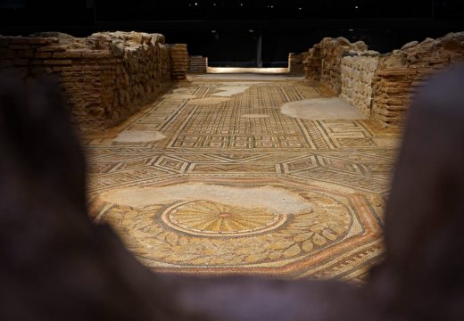
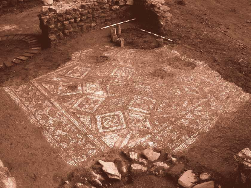
The oldest settlement in the territory is a Phoenician settlement which dates from the 7th century B.C. which is located south of La Loma in Torre de Benagalbón. This was also maintained up until the Roman era, when it was moved to the plains, where the seaside Roman villa in the Villa Antiope Museum are preserved.
It is probably one of the locations which made of this settlement an important spot in both the Phoenician era and specially the Roman era due to its importances as a business centre. Different remains of the first locations for the manufacturing of garum (a fish sauce made with fermented gurs) or salted fish have been found throughout the entire Costa del Sol area.
Most of the human settlements remains are concentrated where the coastal and interior communication rails cross. The control of these allowed the Castillón hill, which in its summit the fortified facility which belonged to the Muslim era castle can still be found. Several Pre-roman ceramic remains were found in its interior.

Manuel Laza's diggings in the castle around 1956

Door of the fortified facility in Castillón hill

Urban layout from the 10th to the 12th century
Andalusian Era
The medieval village of Bezmiliana was located at the base of the hill and towards the beach between the 9th and 15th century. We know its name due to different writings belonging to Muslim authors, which we known thanks to the many archaeological diggings that have happened in the area.
Around the 11th century, during the Andalusian era, it gained major relevance due to the appearance of two mosques, which was something to keep into account at the time. This marks the moment in which Benagalbón was founded, possibly by a Berber tribe during the North African invasions, whose anthroponym gives the town its name, as well as to the municipality created in the 19th century. Another of these urban centers, Cala del Moral, is named due to the existance of different mulberries (‘moreras’ as a plural for ‘moral’ in Spanish) during the Andalusian era. These berries were used to produce silk.
Modern Age


The different records mark 1511 as the year of the depopulation of Bezmiliana. Its population moved to the interior at its name is preserved through the sale of Mixmiliana, located next to the little-used path of Camino de Vélez, which was considered as dangerous due to the Islamic piracy and to the later English one.
During Charles III of Spain’s reign and later years, one of the most important symbols of nowadays’ Rincón de la Victoria was built: the Bezmiliana Fortified House. Due to the constant activity and increase in piracy in the Mediterranean area, Philip II ordereds the construction of different fortified areas in the coastal area, starting from Gibraltar in 1571. As a fun fact, Torre de Benagalbón is named after the construction of this fortification.
Safety revitalised the commercial traffic in the coastal road, making the settlement of eastern Spain’s fishermen between El Cantal and the promontory of Pedrizas much more favourable. They moved to this ‘corner’ (‘rincón’ in Spanish), under the property of the Minim friars which took care of the Sanctuary of the Victory of Málaga (Santuario de la Victoria de Málaga) which from the 15th century onwards had houses and vineyards. This is, most likely, where the name of Rincón de la Victoria comes from, as it is the denomination given to this order.
A historical walk through Rincón de la Victoria
Here is a video which walks through the history of the town during the commemorative events of the creation of Rincón de la Victoria:


